MARCH 2022:
A fund raising effort is initiated by the SBPA to help preserve the Far Away Farm.
The SBPA is working with the American Battlefield Trust to preserve the 121-acre Far Away Farm in the core of the Shepherdstown Battlefield. The farm has a historic home that was present during the battle (but rebuilt later) as well as a barn and workshop. The SBPA has initiated a fund-raising campaign to raise $100,000 to assist the ABT in this $2,000,000 preservation effort. We will transfer 100% of donations marked ‘FAF’ to the ABT for the purchase of the FAF and donors will receive a year’s SBPA membership. Donations can be made through our website, Facebook page or by a mailed check. Thank you for your support.
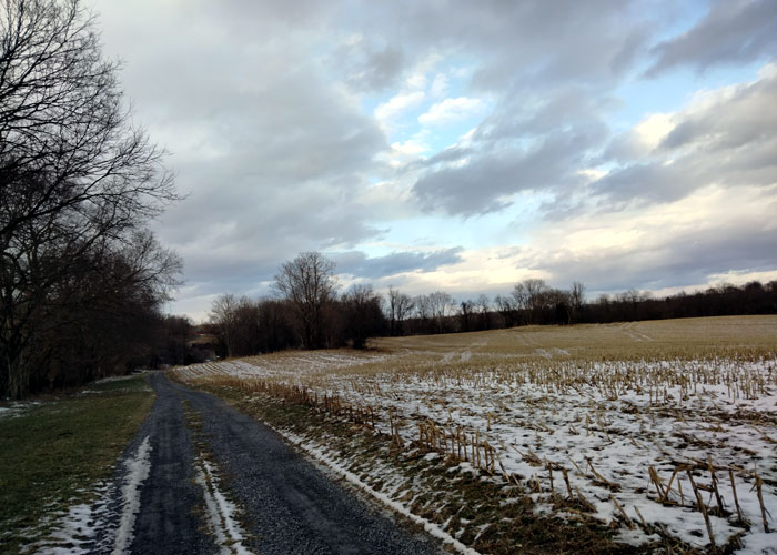
Faraway Farm looking west on the driveway towards the farm’s buildings.
Photo: Mike Nickerson
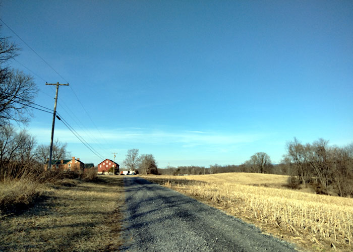
Looking southwest towards the Faraway Farm house, barn and outbuildings.
Photo: Mike Nickerson
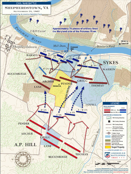
Battle of Shepherdstown
September 20, 1862
The location of the Faraway Farm is shown in yellow with troop locations during the battle and other preserved properties in the battlefield.
Over 622 acres of the core of the Battle of Shepherdstown will be preserved forever as it is today. Or indeed improved by modern battlefield preservation efforts. This land will forever remain as a testament to our forebears who’s commitment to principles made our country what it is today.
Copyright: American Battlefield Trust www.battlefields.org
JUNE 2021:
The Borden Farm Joins the Jefferson County Farmland Protection Program.
In early June, the McKee family signed a deed of conservation easement for the Borden Farm property, completing the process to protect their lands in perpetuity. The new easement increases the amount of protected farmland in Jefferson County to 5,455 acres on 48 farms. More than 90% of the newly protected lands include prime and statewide important agricultural soils. The USDA Natural Resources Conservation Service (NRCS) and the Jefferson County Farmland Protection Board provided funds to purchase the conservation easements.
The 278-acre Borden Farm lies almost entirely within the boundaries of the Core Area of the 1862 Civil War Battle of Shepherdstown and borders 3,000 feet of the Rattlesnake Run, a stream that feeds into the Potomac River at Knott Island, just below Packhorse Ford. The land constitutes Confederate General A.P. Hill’s position in the September 1862 battle where Hill’s forces dislodged Union troops who had pursued General Lee’s army after the Battle of Antietam. The farm pastures cattle and horses and produces hay.
Jim Lighthizer, President of the American Battlefield Trust remarked, “The Trust is thrilled to have been a part of the protection of the Borden Farm at Shepherdstown. That engagement, the final clash of the Antietam Campaign, represents a critical moment in the Civil War’s progress. And I believe that this activity, representing the largest single acreage yet protected on this important battlefield, will also become a moment of note in the story of its preservation.”
“Protecting our county’s farmland goes hand in hand with protecting the quality of life in Jefferson County,” said Elizabeth Wheeler, the Board’s Program Director. “Local farms provide us with healthy food, support a diverse economy, and protect water supplies, wildlife habitat and the scenic and historical landscapes that make Jefferson County such a beautiful place to live and visit.”
About the Jefferson County Farmland Protection Board
The Jefferson County Farmland Protection Board was established under a state law passed in 2000 that allows West Virginia counties to levy a transfer tax on real estate to purchase development rights from landowners who wish to protect their land for agricultural purposes.
An agricultural conservation easement is a voluntary, legally recorded deed restriction that is placed on a specific property used for agricultural production. It is a flexible legal tool that enables landowners to permanently protect the agricultural, natural, scenic and historic values of their property from development and subdivision. Property owners retain full use and ownership of the land. Because an easement is perpetual, it is transferred with the property when the property is sold, thereby forever protecting it. For more information about the Jefferson County Farmland Protection Board, contact the Board at: 304/724-1414 or [email protected].
AUGUST 2019:
Conservation Easement Placed on 24 Acres of Shepherdstown Battlefield Land.
FOR IMMEDIATE RELEASE
August 28, 2019
Contact: Martin Burke, Chair, Jefferson County Historic Landmarks Commission
p: (304) 876-3883
e: [email protected]
Shepherdstown, WV – Protection of the land constituting Confederate General A.P. Hill’s right flank in the 1862 Battle of Shepherdstown advanced July 31 with the placement of a conservation easement on 24 acres of Potomac River Bluff where Hill’s forces dislodged Union troops who had pursued General Lee’s army after the Battle of Antietam. While Hill’s right flank did not see the dramatic action of his left flank, where miscommunication and other problems resulted in decimation of the 118th Pennsylvania Regiment, it played an important supporting role.
The Jefferson County Historic Landmarks Commission (JCHLC) acquired the 24 acres on Hill’s right flank with the assistance of the American Battlefield Trust and the National Park Service’s American Battlefield Protection Program, which required placement of a conservation easement to permanently protect the property. That document was signed July 31 with the Land Trust of the Eastern Panhandle as the easement holder, responsible for its monitoring and enforcement. The easement area includes a neck running down to River Road, with the majority of the property on the crest of the bluff. It consists of four parcels, two most recently owned by Wayne Eyler and two by Noah Merkham.
A house on one of the Eyler parcels has been demolished, leaving the entire, partially wooded 24 acres without structures, which is how it must remain under the terms of the conservation easement. This easement is a great example of opportunities that exist to protect land for the purposes of protecting rivers and water quality. “We commend the Jefferson County Historic Landmarks Commission and the Land Trust of the Eastern Panhandle for their work in using land conservation to protect our drinking water sources, such as the Potomac River,” said Tanner Haid with WV Rivers Coalition.
Conservation easements already protect 26 acres of Historic Landmarks Commission land upstream, at the intersection of Trough and River Roads, where both armies had crossed the Potomac at Packhorse Ford and where the heaviest fighting occurred. In addition, the Land Trust of the Eastern Panhandle and the Jefferson County Farmland Protection Board hold easements on 57 acres of privately owned land further up Trough Road, protecting it from development.
The Historic Landmarks Commission, Farmland Protection Board and Land Trust of the Eastern Panhandle continue to look for opportunities to protect additional land in the Shepherdstown Battlefield area.
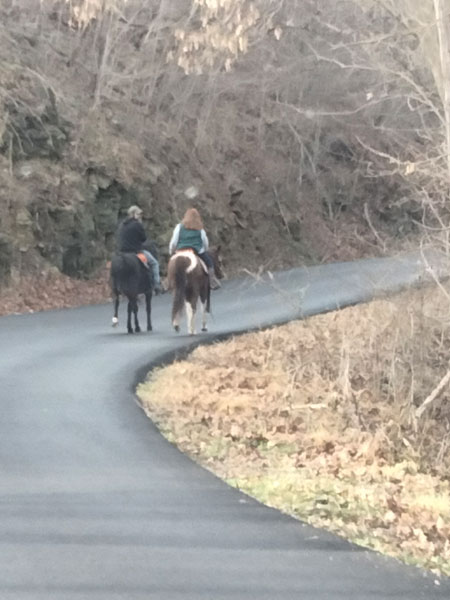
Horse riders on River Road along the riverside Battlefield Park, December 2021. Photo: Mike Nickerson
NOVEMBER 2017:
Conservation Efforts Move Forward at the Shepherdstown Battlefield.
For immediate release – November 20, 2017
Contact: Martin Burke, Chair, Jefferson County Historic Landmarks Commission
p: (304) 876-3883
e: [email protected]
Shepherdstown, WV – Preservation at the site of the brief but significant September 1862 Battle of Shepherdstown moved a step forward Monday with signature of a conservation easement permanently protecting an additional 2.5 acres along the Potomac River at the intersection of River and Trough Roads.
Confederate troops made a dramatic overnight retreat from the Battle of Antietam across Pack Horse Ford to that intersection, after which they moved up Trough Road. Union troops pursued but were forced back across the Potomac in an action that is credited with convincing the Confederate forces not to invade Maryland again in 1862 and Union forces to not attempt further pursuit of General Lee on the southern side of the Potomac.
The 2.5 acres are located on the downstream side of the intersection, adding to the 16 acres already preserved by conservation easement on the upstream side of the intersection. The land now protected includes not only the key half mile of riverbank but also the heights overlooking the ford – heights temporarily held by Union forces and then by Confederate forces, who used the location to bombard fleeing Yankees.
All 18 acres are owned by the Jefferson County Historic Landmarks Commission, with the conservation easement held by the Land Trust of the Eastern Panhandle. Funding for purchase of the additional 2.5 acres came from the Civil War Trust and from the Shepherdstown Battlefield Preservation Association, which has played a crucial role in finding funding for the protection of these properties. Reimbursement to the Civil War Trust by the National Park Service’s American Battlefield Protection Program (ABPP) was conditioned on placement of a conservation easement on those acres.
ABPP maps show both a core area and a study area for the congressionally-recognized Battle of Shepherdstown. More recently, a National Park Service special resources study recommended that the key area of the battlefield be added to the Antietam National Battlefield, a recommendation dependent on congressional action. The 18 acres owned by the Historic Landmarks Commission would become the core portion of that addition, with other additions only as landowners agree.
The Historic Landmarks Commission hopes to acquire additional land in the battle area. Even land that it does not buy can be protected by conservation easement through the Land Trust, which already holds easements on 16 acres uphill along Trough Road, leading away from the Potomac. That land continues in private ownership but can never be developed further.
The land upstream from the intersection of River and Trough Roads was the site of a Cement Mill that supplied hydraulic cement for the construction of the Chesapeake and Ohio Canal and continued in operation until 1901. Still visible are the cement mill kilns below River Road, where Union soldiers took cover, and the ruins of some of the cement mill buildings.
Additional information about these programs is available from Martin Burke, Chairman of the Historic Landmarks Commission, 304-876-3883, or from Grant Smith, President, Land Trust of the Eastern Panhandle, 304-876-2583.
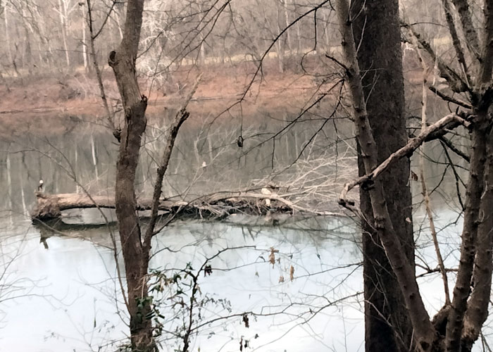
A bald eagle resting on a tree grounded above the cement mill dam in the riverside Battlefield Park, December 2021. Photo: Mike Nickerson
JULY 2017:
26 Acres at Shepherdstown Battlefield Protected Forever.
For immediate release – July 3, 2017
Contact: Martin Burke, Chair, Jefferson County Historic Landmarks Commission
p: (304) 876-3883
e: [email protected]
Shepherdstown, WV – Last week with the aid of the Civil War Trust, the Jefferson County Historic Landmarks Commission took title to 26 acres of battlefield land near Shepherdstown. A portion of the project was funded by grants from the American Battlefield Protection Program through the National Park Service and the balance through private donations to the Civil War Trust. The Land Trust of the Eastern Panhandle will hold a conservation easement on the property.
The preservation of this historically significant land is an ongoing collaboration between the Landmarks Commission and the Shepherdstown Battlefield Preservation Association. The Battle of Shepherdstown took place on September 19-20, 1862 in the aftermath of Antietam. General Lee’s army retreated into Virginia at Pack Horse Ford on the night of the 18th, leaving a rearguard on the bluffs surrounding the ford. Fitz John Porter and his Union troops arrived on the morning of the 19th. Artillery fired from both sides of the Potomac for two days. On the 20th, a reconnaissance in force crossed the river, and a bloody battle ensued in the cliffs and ravines around the Shepherdstown cement mill. The battle was a Confederate victory, but marked the end of Lee’s Maryland Campaign.
This parcel is one of several tracts recently acquired for permanent protection and ultimate donation to the NPS.
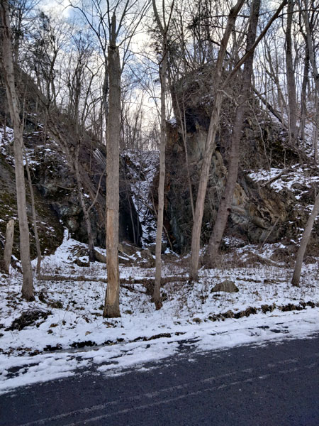
A ravine in the cliffs above the Battlefield Park resulting from limestone removal for cement production, January 2022. Photo: Mike Nickerson
JULY 2015:
Final Special Resources Study Released by the National Parks Service, Interior Department
Interior Dept. Releases Final Study of Shepherdstown Battlefield
For Immediate Release – July 27, 2015
Shepherdstown, West Virginia
In early July, The Department of Interior released the final study documents of the National Park Service’s (NPS) Special Resource Study (SRS) of the Shepherdstown Battlefield. The Battle of Shepherdstown occurred on September 19 and 20, 1862 involving approximately 8,000 to 10,000 troops and resulted in 677 casualties.
The SRS concluded that the 510 acre site of the 1862 Battle of Shepherdstown would be preferably included within the Antietam National Battlefield Park. The SRS studied various options and possible boundary adjustments including an assessment of including the Shepherdstown site within the Harpers Ferry National Historical Park. “As such, each of these boundary adjustment options is included in the study alternatives, with Antietam National Battlefield being the preferable option due to its historical and geographical connections to the Battle of Shepherdstown.”
The 1862 Maryland Campaign of the Army of Northern Virginia included battles of South Mountain, Harpers Ferry, Antietam and a battle ending near Shepherdstown in what is now West Virginia. The SRS concluded that: “The inclusion of the Shepherdstown battlefield into Antietam National Battlefield would provide visitors the opportunity to have an expanded understanding of the events directly following the Battle of Antietam and the culmination of the Maryland Campaign. The SRS further concludes it “would propose to adjust the existing boundary of Antietam National Battlefield to include areas of the Shepherdstown battlefield that contribute to an understanding of the significance of the Battle of Antietam and the Maryland Campaign.”
In early 2012, the NPS held two scoping meetings seeking public comments regarding the proposed SRS. “In total, approximately 136 people attended the scoping meetings. … Public response received by the National Park Service was predominately supportive of the study and enthusiastic concerning the interpretation and protection of the Shepherdstown battlefield.” The preliminary SRS was released in August 2014 and a public review period was conducted for two months. During this period, 334 individuals corresponded with the NPS. Two public meetings were held in September attended by approximately 93 individuals. “Commenters expressed overwhelming support for” … the management option that the…“Antietam National Boundary Adjustment as the most effective and efficient way to preserve the Shepherdstown battlefield.”
“If Congress were to authorize a legislative boundary that would encompass the Shepherdstown battlefield as part of … Antietam National Battlefield, there would be no change to existing landownership…” “Any change to land ownership or use would be in the future as the National Park Service is able to acquire battlefield land from willing sellers and donors.”
The effort to involve the Federal government in helping to save and preserve the site of the Battle of Shepherdstown has been the result of the work of the Shepherdstown Battlefield Preservation Association, Inc. (SBPA) and its individual members. SBPA is a non-profit corporation, organized in 2004 dedicated to saving and preserving the core of the site of the Battle of Shepherdstown. Approximately 105 acres have been saved through conservation easements and land purchases. Approximately $1.1 million has been raised to save battlefield land through grants and membership contributions during the last ten years. If you would like to help save more of the battlefield and learn more about SBPA, please go to: www.battleofshepherdstown.org.
NOVEMBER 2014:
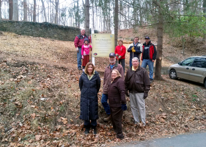
Another piece of land preserved in the Battle of Shepherdstown. A sign erection by SBPA members on Trough Road. Photo: Dr. Rosemary Nickerson.
APRIL 2014:
CEMENT MILL PURCHASE CELEBRATED
On Saturday morning, April 5, a sign was erected and dedicated to commemorate the purchase and preservation of the Historic Cement Mill property. This property is part of the site of the 1862 Battle of Shepherdstown. The property contains structures from an 1829 Cement Mill that was the beginning of the Industrial Revolution in Jefferson County. The structures include the ruins of the mill, six kilns on the bank of the Potomac River, a large kiln south of River Road and the remnants of an office building. Some of the kilns on the river show damage from Union artillery shells sustained during the Battle of Shepherdstown.
In late 2011, the Civil War Trust purchased 18 acres of the Cement Mill property and in late 2013, another small parcel, contiguous to the Cement Mill property, was purchased. The entire property was deeded to the Jefferson County Historic Landmarks Commission (HLC). Ultimately, the HLC intends to donate the parcel to the National Park Service (NPS). A conservation easement has been placed on the property and it has been included in the National Register of Historic Places.
The total cost of the purchases was $445,000. The funds to complete the purchases came from the Land and Water Conservation Fund administered by the NPS, WV Transportation Enhancement Grants, the Civil War Trust, Save Historic Antietam Foundation Inc., the office of Governor Earl Ray Tomblin through the efforts of then-Delegate John Doyle, the Shepherdstown Battlefield Preservation Association Inc., and the American Battlefield Protection Program of the NPS.
The Civil War Trust has negotiated to purchase another parcel contiguous to the Cement Mill property which will result in the preservation of 20.2 acres of the original Cement Mill property. Importantly, the Cement Mill property is contiguous to 59 acres already saved through the use of conservation easements. In total, 104 acres of the core of site of the Battle of Shepherdstown have been saved and preserved.
This effort has been the result of the work of the Shepherdstown Battlefield Preservation Association Inc (SBPA) and its individual members. SBPA is a non-profit corporation, organized in 2004 dedicated to saving and preserving the core of the site of the Battle of Shepherdstown. Slightly more than $1 million has been raised through grants and membership contributions during the last ten years.
DECEMBER 2013:
West Virginia Delegate John Doyle and the Jefferson County Historic Landmarks Commission announced that the Landmarks Commission completed the purchase of the historic Cement Mill property. The property is an 18 acre site on the Potomac River. The property contains structures from an 1829 Cement Mill that was the beginning of the Industrial Revolution in Jefferson County and is also part of the site of the 1862 Battle of Shepherdstown. The structures include the ruins of the mill, six kilns on the bank of the river, a large kiln south of River Road and the remnants of an office building. Some of the kilns on the river show damage from Union artillery shells sustained during the Battle of Shepherdstown.
The site was purchased for $375,000 from a private individual whose family owned it for more than 100 years. The funds used to purchase the land came from two $100,000 West Virginia Transportation Enhancement Grants garnered by SBPA for the County with $50,000 in matching funds from the Civil War Trust (CWT). When it became apparent that the owner was willing to sell the property additional funds were sought and the CWT, the Save Historic Antietam Foundation, SBPA provided those funds. Delegate John Doyle was able to obtain $25,000 from West Virginia Governor Earl Ray Tomblin that was still needed to purchase the property.
NOVEMBER 2013:
Not entirely a surprise, but the Circuit Court judge overruled himself and decided against our claim that the Jefferson County Planning Commission (PC) violated the West Virginia Open Governmental Proceedings Act (OGPA) when the PC reached a secret agreement with the developer of Far Away Farm. He did this despite the fact that the PC did not, on their meeting agenda, properly list the proposed agreement, did not the minutes of the meeting in a timely fashion, all in violation of the OGPA. He vacated his prior ruling that the PC had violated the OGPA.
No matter what the outcome of his ruling we knew that we would be back at the West Virginia Supreme Court of Appeals (WVSCA) next. We plan to file a petition with the WVSCA as soon as possible. One comforting factor, as we understand, is that the Circuit Court judge has been, in the last several years, overruled by the WVSCA more than any other WV Circuit Court judge.
JULY 2011:
In a secret agreement between the attorneys for Far Away Farm and the Jefferson County Planning Commission, the Commission granted the developer a 3-year extension of both it’s Community Impact Statement and Conditional Use Permit. SBPA’s Attorney discovered the agreement and filed a petition with the Circuit Court in an attempt to invalidate that agreement.
May 2011:
The attorneys for Far Away Farm filed a petition with the Circuit Court asking for a reversal of the Planning Commission’s denial of an extension of the Community Impact Statement for the proposed development. SBPA filed a petition with the Circuit Court asking to be accepting as “intervenors” in this case.
October 2010:
The attorneys for Far Away Farm requested that the Jefferson County Planning Commission grant an extension of the proposed development’s Community Impact Statement which was about to expire. The Planning Commission unanimously denied the extension.
JUNE 2009:
SBPA established a Historical Advisory Board (HAB) organized by Dr. Peter Carmichael, the West Virginia University (WVU) Eberly Professor of Civil War Studies. Dr. Carmichael stated that “the outpouring of support from the academic community in forming a Historical Advisory Board attests to the undeniable historic importance of the Battle of Shepherdstown. Among the scholars who have joined the board, all are recognized experts in the field of Civil War history, and many have received national attention for their work, including James McPherson, Gary W. Gallagher, Elizabeth Pryor, and William Link. Their support of the Shepherdstown Battlefield Preservation Association is indispensable to saving what they uniformly believe is sacred historical ground.”
MARCH 2009:
Legislation introduced by Senator Robert C. Byrd was passed by both the United States Senate and House of Representatives and signed into law by President Obama on March 30, 2009. At a Senate hearing in 2008, representatives of the National Park Service spoke in support of Senator Byrd’s proposed legislation. Included in the “Omnibus Public Land Management Act of 2009” was a section that could ultimately save and preserve the site of the 1862 Battle of Shepherdstown.
Presented below is the section of the law that will begin the process that could lead to the Shepherdstown battlefield site into being included within either the boundary of the National Parks at Antietam or Harper’s Ferry:
SEC. 7205. SHEPHERDSTOWN BATTLEFIELD, WEST VIRGINIA.
(a) Special Resources Study – The Secretary of the Interior (referred to in this section as the `Secretary’) shall conduct a special resource study relating to the Battle of Shepherdstown in Shepherdstown, West Virginia, to evaluate —
(1) the national significance of the Shepherdstown battlefield and sites relating to the Shepherdstown battlefield; and
(2) the suitability and feasibility of adding the Shepherdstown battlefield and sites relating to the Shepherdstown battlefield as part of–
(A) Harpers Ferry National Historical Park; or
(B) Antietam National Battlefield.
(b) Criteria- In conducting the study authorized under subsection (a), the Secretary shall use the criteria for the study of areas for potential inclusion in the National Park System contained in section 8(c) of Public Law 91-383 (16 U.S.C. 1a-5(c)).
(c) Report- Not later than 3 years after the date on which funds are made available to carry out this section, the Secretary shall submit to the Committee on Energy and Natural Resources of the Senate and the Committee on Natural Resources of the House of Representatives a report containing the findings, conclusions, and recommendations of the study conducted under subsection (a).
(d) Authorization of Appropriations- There are authorized to be appropriated such sums as are necessary to carry out this section.
OCTOBER 2008:
On Friday 10/17/08, West Virginia Governor Joe Manchin presented to Jefferson County and SBPA a $100,000 Transportation Enhancement Grant to be used to purchase land on the site of the 1862 Battle of Shepherdstown. The presentation occurred in McMurran Hall on the campus of Shepherd University. This is the second Transportation Enhancement Grant given to Jefferson County to purchase land on the battlefield site. In 2006, the County received a $100,000 grant and the Civil War Preservation Trust agreed to provide the required matching funds.
SEPTEMBER-NOVEMBER 2008:
In September 2008, SBPA’s attorney filed a petition in the United States Supreme Court (USSC) asking for a review and summary judgement reversing the decision of the WVSCA. In November, the USSC refused to hear that appeal.
SBPA believes that the Jefferson County Planning Commission has the ability to challenge the WVSCA’s decision in the Federal Court. We await action by the Jefferson County Planning Commission.
AUGUST 2008:
Under legal duress, the Jefferson County Planning Commission granted the Conditional Use Permit (CUP) to the developer. The Planning Commission indicated that they will pursue further legal options, perhaps in Federal Court.
MAY-JUNE 2008:
SBPA and the JCBZA filed an appeal with the WVSCA asking for a reconsideration of their decision. The filings cited the many instances that the WVSCA decision violated a number of legal principles. The WVSCA refused to reconsider their decision. SBPA’s attorney started work on filing an appeal in the United States Supreme Court.
APRIL 2008:
The United States Senate Committee on Energy & Natural Resources held a hearing regarding Senate Bill 1633. Jefferson County Commissioner Jim Surkamp, with the aid of SBPA, testified and cited the national significance of the Battle of Shepherdstown and the sites imminent danger of being developed for residential houses.
In a shocking decision, the West Virginia Supreme Court of Appeals (WVSCA) reversed the lower court decision and ordered the Jefferson County Planning Commission (JCPC) to grant the developer a Conditional Use Permit (CUP) to build 152 houses in the core of the site of the Battle of Shepherdstown. The decision ignored the fact that the JCPC was not a party to the decision to deny the CUP nor was it a party to the appeal. More importantly, neither the County’s Ordinances nor state law authorizes the JCPC to grant CUPs.
MARCH 2008:
Once again, and unfortunately, the site of the Battle of Shepherdstown was included in the Civil War Preservation Trust’s list of endangered battlefields. The Shepherdstown site was included as an “At Risk” battlefield in the report entitled “History Under Siege”. Click here to see the full report.
Oral arguments were presented to the West Virginia Supreme Court of Appeals by attorneys for the Jefferson County Board of Zoning Appeals (JCBZA) and SBPA. Their arguments refuted the legal and factual basis for the developer’s reasons appealing the Circuit Court’s decision to deny the permit to build on the Shepherdstown site. However, by the questions asked by the Justices, it was apparent that a political decision was in the offing rather than a legal decision.
NOVEMBER 2007:
On November 15, 2007, the Jefferson County Commission, by a vote of 4 to 1, approved a motion to establish a $100,000 fund to be used to purchase land within the site of the 1862 Civil War Battle of Shepherdstown. This was the first concrete evidence that our local elected officials support SBPA’s effort to preserve the site. While the amount of money pales in comparison to the $644,000 in grants and conservation easements that SBPA has been able to accumulate in preserving the site, it is a good first step by our County Commission. At the following County Commission meeting, the Commissioners established a $100,000 fund by resolution. Commissioners F.Morgan, A.Morgan, Surkamp and Corliss all voted in favor of the resolution, while Commissioner Manuel continued his desire to stymie SBPA and voted against the resolution.
The first full length account of the Battle of Shepherdstown was published by Schroeder Publications. Entitled: “Shepherdstown: Last Clash of the Antietam Campaign September 19-20, 1862” the book is a 256 page account of the battle with more than 80 related photos, illustrations and maps. Its author, Thomas A. McGrath, spent 10 years researching the battle and has brought together many diverse primary sources detailing both the tactical aspects of the battle and the human element.
JUNE 2007:
Senator Robert C. Byrd introduced legislation asking for authorization for a National Park Service “Special Resources Study” to document the site of the 1862 Battle of Shepherdstown. This is the first of several steps that are necessary for the Shepherdstown site to be included within the boundaries of an existing National Civil War Park.
JANUARY 2007:
The developer filed a petition with the West Virginia Supreme Court of Appeals asking the court to reverse the decisions of the Circuit Court and the Board of Zoning Appeals. SBPA responded to the developer’s petition challenging their assertions and asking the court to uphold the previous decisions.
DECEMBER 2006:
-The IRS granted SBPA tax exempt status under Section 501(c)(3) of the IRS Code.
-On December 8, two members of SBPA signed conservation easement documents preserving 59 acres of the battlefield from future development. The Land Trust of the Eastern Panhandle oversaw the effort which was funded by the National Park Service’s American Battlefield Protection Program and the Jefferson County Farmland Protection Board. The Civil War Preservation Trust and the SBPA were instrumental in effecting the easements. Including 25 acres donated to a conservation easement, there are now 84 acres on the site of the Battle of Shepherdstown that are safe from future development. SBPA continues its effort to save the remaining 216 acres.
Note: In the image below, the area in red is the battlefield as identified by the West Virginia State Historian and the American Battlefield Protection Program of The National Park Service. The area outlined in blue represents the 300 acres that SBPA is trying to preserve. The areas shaded in blue represents the acreage now under conservation easements.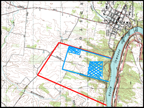
SEPTEMBER 2006:
On September 18, the Jefferson County Circuit Court issued its decision upholding the BZA’s denial of a Conditional Use Permit to Faraway Farms LLC to build 152 houses on the site of the Battle of Shepherdstown. SBPA expects that the developer will appeal the Circuit Court’s decision to the West Virginia Supreme Court.
AUGUST 2006:
West Virginia Governor Joe Manchin presented Jefferson County with a $100,000 grant to be used solely for the purchase of land within the site of the Battle of Shepherdstown. SBPA learned of the availability of the grant through West Virginia Delegate John Doyle who initiated the application process. SBPA filed the application on behalf of Jefferson County. The Civil War Preservation Trust agreed to provide the necessary matching funds of $25,000.
JUNE 2006:
In an effort to create a National Civil War Battlefield Park, SBPA has enlisted the help of West Virginia Senator Robert C. Byrd and Congresswoman Shelley Moore-Capito. An Act of Congress is required to expand the boundaries of an existing National Park to include the site of the Battle of Shepherdstown. Both Senator Byrd’s staff and that of Congresswoman Capito are in the early stages of researching the process. Hopefully, the boundaries of either Harper’s Ferry or Antietam National Park will be expanded to include the Shepherdstown site. If that is accomplished, SBPA will attempt, through the West Virginia Congressional Delegation, to obtain an appropriation the Federal budget to purchase land within the core of the battlefield.
MARCH 2006:
The Civil War Preservation Trust’s latest endangered battlefield report entitled “History Under Siege” listed the site of the Battle of Shepherdstown as an “At Risk” battlefield. The report lists the 20 battlefields that are in danger of being lost due to development. The list is divided between the 10 battlefields identified as “Most Endangered” and the 10 “At Risk” battlefields. To quote the report: “What is the value of land that hundreds of men paid for with their lives? We believe it to be priceless.”Click here to see the full report.
NOVEMBER 2005:
-SBPA made an offer to purchase the farm from the developer that was rejected almost immediately with no counter offer made.
-SBPA applied for grants to fund the purchase of Faraway Farm and several other properties contiguous to the farm. Three property owners on the battlefield site are pursuing conservation easements with the Eastern Panhandle Land Trust and the Farmland Protection Board in order to prevent development on their property in perpetuity.
-The Jefferson County Commission held a public hearing in order to ascertain public interest in creating a Shepherdstown Civil War Battlefield Park. More than 70 residents attended. After the developer’s attorney again denied that there was any proof that a Civil War Battle had taken place on the farm, 20 Jefferson County residents spoke in favor of establishing a park.
-The Jefferson County Commission unanimously approved three agenda items that support the establishment of a Civil War Battlefield Park:
1) A resolution supporting SBPA’s efforts.
2) A letter to the Harper’s Ferry National Park asking that the site of the Battle of Shepherdstown be included in their 5-year master plan.
3) Letters to the West Virginia Congressional Delegation urging them to allocate federal funds to establish the Shepherdstown Civil War Battlefield Park.
-The Jefferson County Circuit Court ruled against the developer on two of three contested issues. A hearing for the last issue has yet to be scheduled.
-SBPA filed for 501(c)(3) status as a charitable trust.
-Dr. Thomas Clemens, historian and President of the Save Historic Antietam Foundation, Inc. agreed to serve as an SBPA Board Member.
AUGUST 2005 – October 2005:
-The BZA held a post-CAM hearing to resolve all issues and to determine if the proposed development was compatible with the neighborhood. SBPA presented data showing that the average lot size in the neighborhood was 14.7 acres and that the proposed subdivision was clearly not compatible with the rural neighborhood. Maps and other documentation were also presented showing that the farm was located on part of the core of the Battle of Shepherdstown. The BZA denied the developer’s CUP application based on the high density of the proposed subdivision and the highway problems that such a development would cause. The historical nature of the farm played no role in the decision.
-Alan Rowe of the West Virginia Division of Culture and History found that the site of the Battle of Shepherdstown had retained sufficient physical integrity necessary to be eligible for inclusion in the National Register.
-SBPA met with the West Virginia state legislators representing the three-county Eastern Panhandle and presented petitions signed by 500 Eastern Panhandle residents supporting saving the battlefield site as well as letters of support by many noted historians. A resolution was unanimously passed and signed by the legislators supporting the preservation of the battlefield.
-The Board of Historic Shepherdstown unanimously signed a resolution supporting SBPA’s efforts.
-The Quad State (Maryland, Pennsylvania, Virginia, and West Virginia) Legislative Conference members unanimously signed a resolution supporting SBPA’s efforts.
-The developer listed the farm for sale, advertising it as part of a Civil War Battlefield.
-The Shepherdstown Town Council unanimously signed a resolution supporting SBPA’s efforts.
-The developer filed suit challenging the BZA decision on 3 issues.
JULY 2005:
Having amassed irrefutable evidence that Faraway Farm is part of the core of the battlefield, CUSFF members voted to change the organization’s name to the Shepherdstown Battlefield Preservation Association (SBPA) with the purpose of saving and preserving the remaining 282 acres of the battlefield site from any further development.
JUNE 2005:
The Circuit Court agreed that the CUSFF petition had merit and a hearing would be scheduled for a later date.
MAY 2005:
At the urging of local historians, CUSFF began to focus more on the historic nature of the farm and obtained support via emails and letters from the Civil War Preservation Trust, the American Battlefield Protection Program of the National Park Service, the Superintendent of the Antietam National Battlefield Park and James McPherson, Pulitzer Prize winning historian. CUSFF representatives met with Dr. Thomas Clemens and the Board of Save Historic Antietam Foundation, Inc. regarding saving Faraway Farm as an important Civil War battlefield site.
APRIL 2005:
An 8-hour long Compatibility Assessment Meeting (CAM) was held before the County’s Zoning Administrator; the petition before the Circuit Court notwithstanding. The purpose of the CAM is to determine if the proposed development is compatible with the surrounding neighborhood. Residents of the neighborhood asked for many changes in the proposed development totaling 106 specific issues. The meeting resulted in 67 unresolved issues that the BZA was to address in its next meeting.
JANUARY – MARCH 2005:
The County’s Board of Zoning Appeals (BZA) held a public hearing and the CUSFF appeal was rejected. The CUP application was allowed to proceed to the next step. CUSFF filed a petition with the Jefferson County Circuit Court challenging the BZA decision. The petition cited administrative issues that the BZA failed to address, their interpretation of sections of the Zoning Ordinance, and an apparent conflict of interest of one of the members of the BZA.
OCTOBER – NOVEMBER 2004:
A Maryland-based developer applied for a Conditional Use Permit (CUP) to build 152 homes on a 122-acre farm named Faraway Farm in a rural section of Jefferson County, West Virginia. He planned to set aside 10 acres with a 200 year-old farmhouse and build on the remaining 112 acres. The farm is a significant part of the site of the Sept. 1862 Civil War Battle of Shepherdstown (Boteler’s Ford). Citizens United to Save Faraway Farm LLC (CUSFF) was formed by local residents with the initial purpose of keeping the proposed development of Faraway Farm within the limits of rural zoning since the County’s Zoning Ordinance does not recognize the importance of historic sites in deciding the fate of proposed high-density residential developments. CUSFF filed a 200-page document appealing specific measurements by the County Zoning Administrator that would have resulted in approval of the proposed subdivision. The CUSFF appeal also cited a number of administrative errors in the developer’s CUP.
26 Acres at Shepherdstown Battlefield Protected Forever.