2024 Maps
Updated August 1, 2024: We have made some critical updates to the maps of the Battle of Shepherdstown. Please see these new versions, also available as PDF files to download, for the most accurate details yet. Dr. Mike Nickerson
Updated May 17, 2024: We have completed the NEW battle maps that we hope are the most accurate to date after 27 versions and about 5 months.
There are 3 maps of the Battle of Shepherdstown: September 18-19, 1862; September 20 early morning; and September 20 late morning. As opposed to a single map, we felt the expansion to 3 maps gave us the most clarity on the different phases of the Confederate crossing, Sept 19 and then the 20th.
There are significant changes for sure, but which we felt were supported by the actual after-action accounts of the folks involved, including Lovell, A.P. Hill, Barnes, etc. Fortunately Tom McGrath provided access to these invaluable first hand accounts.
Pre-2024 Maps: We can see the historical progression as we discover more information.
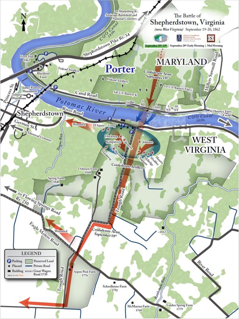
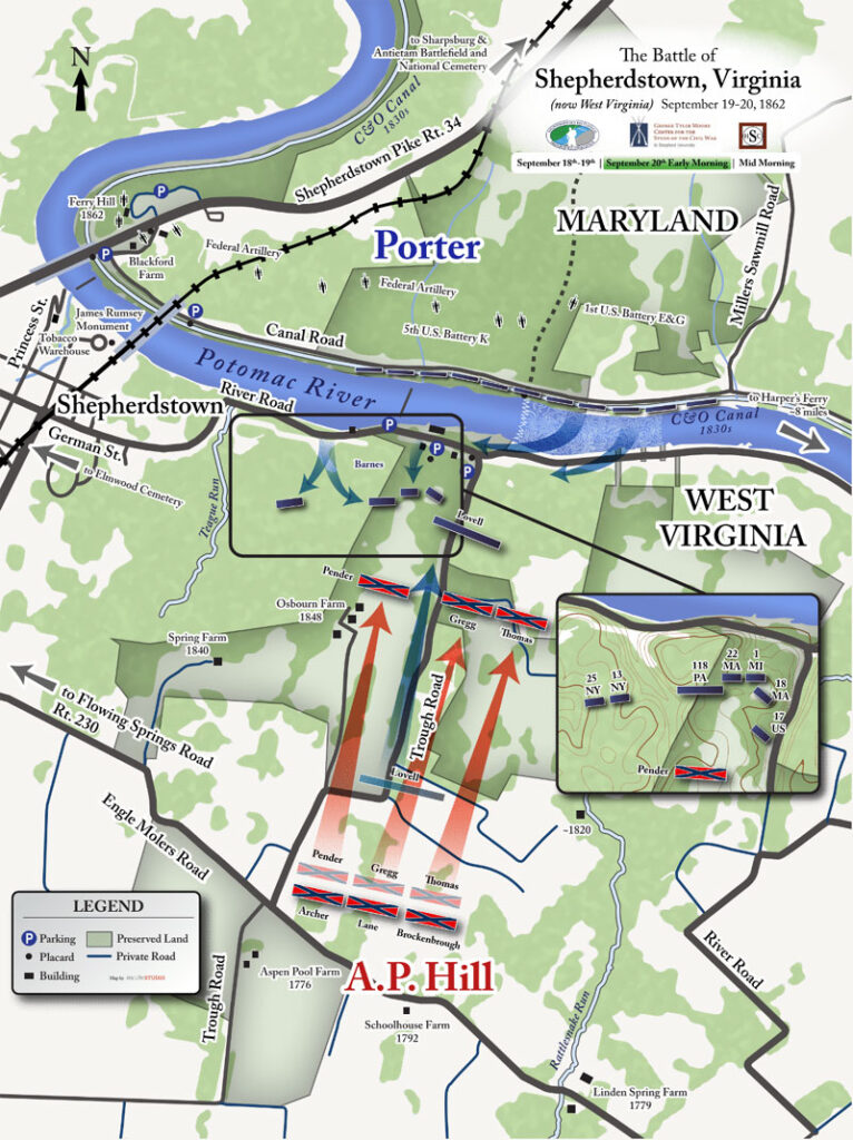
Troop Location September 19th, 1862
After retreating from the site of the Battle of Antietam and crossing the Potomac River at Boteler’s Ford, General Robert E. Lee left the small brigades of Lawton and Armistead with MG Wm. Pendleton in charge to cover the retreat. In late afternoon, Sept. 19, 1862, an artillery battle ensued and the Confederates with only 600 infantry and outgunned by 2 to 1 retreated from the south bank as the Union troops crossed the river. Pendleton panicked and left the battlefield looking for help. After finding General Lee at midnight, Pendleton informed him that all was lost at the ford. Meanwhile, the Confederate troops saved most of their artillery and escaped the battlefield. The Union troops, after crossing the river and forcing the Confederate retreat, returned to the north bank.
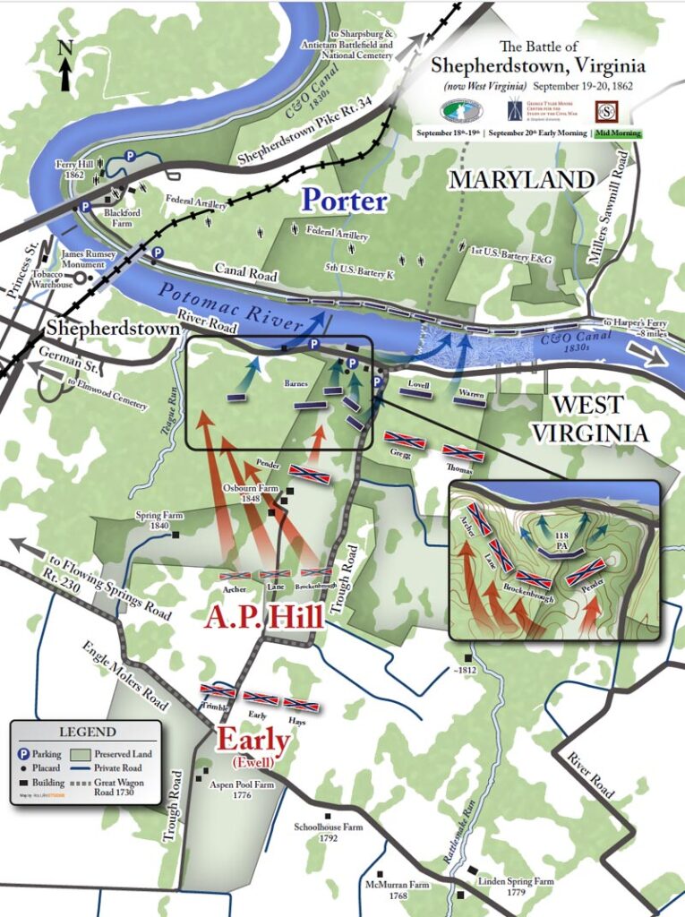
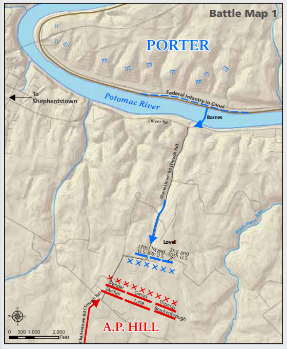
Troop Locations September 20th, 1862: 6am – 10am
Early morning on Sept. 20, two Union Army units returned to the south bank to retrieve 4 artillery pieces left by the Confederates. As these units returned to the north bank, BG Geo. Sykes crossed the river with his 2nd and 3rd Brigades followed by the 1st Brigade of the 1st Division, commanded by Col. James Barnes.
The 3000 Union troops crossed the Potomac and the 2nd Brigade secured the bluffs near the ford while the 1st Brigade was ordered to seek out the enemy but go no further than the second tree line, approximately 1 ½ miles south of the river. At the same time, MG Thomas “Stonewall” Jackson, with BG A.P. Hill’s Light Division, returned to the river to stem the Union advance. The two armies clashed near Engle Molers Road at about 10:00AM. At about this time, Barnes’s Brigade secured the bluffs above the dam.
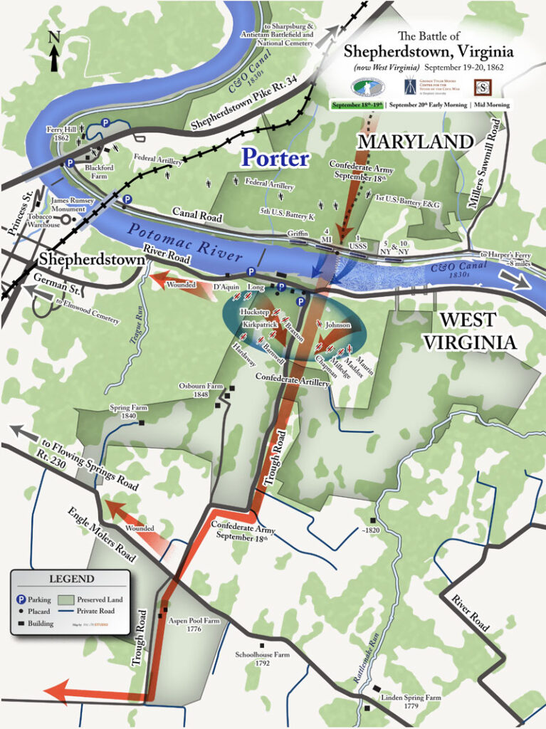
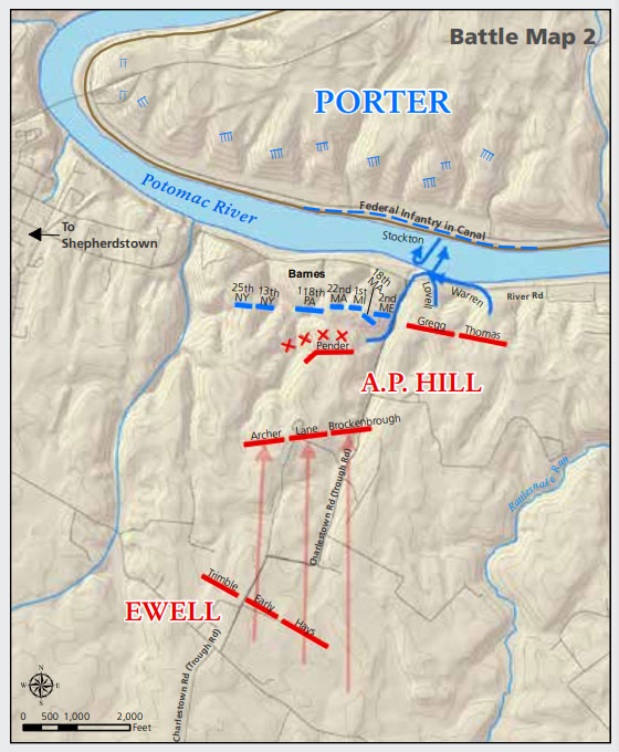
Troop Movement September 20th, 1862: 10am – 12pm
The Union army was out manned by about a 2 to 1 margin and was ordered to retreat. Hill’s Light Division was deployed pushing the Union troops back toward the river. While the troops moved toward the river the Union artillery continued to fire. For about two hours the two armies were engaged as the Union troops made their way back to the river.
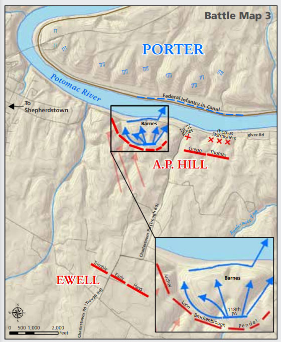
Troop Locations September 20th, 1862: 12pm – 3pm
Colonel Charles Prevost, Commander of the 118th Pennsylvania Volunteers, known as the “Corn Exchange Regiment”, did not comply with the order to retreat because it did not come through “proper” channels. In the midst of the chaos, the green 118th Pennsylvania found itself isolated and outflanked. Besides having only been in the service for three weeks, the men were armed with many rifles that malfunctioned. The Pennsylvanians panicked and made a rush for the river, some fell from the bluffs, and others sought refuge in the nearby cement mill and kilns. The men of the 118th continued under fire while attempting to get back to the Maryland shore and the dry bed of the C&O canal. The 118th PA regiment, having never been in action before and with many defective weapons, was decimated, suffering 40% casualties.
In total the battle involved about 9000 troops and resulted in 677 casualties, about equally divided between both armies. As a consequence of the battle, Lee changed his plan to resume “The Maryland Campaign” and rather than advance into Maryland at Williamsport, he ordered the Army of Northern Virginia to retreat toward Winchester.
The battle lasted less than an hour and the Confederates withdrew to escape the wrath of Union artillery fire from across the river. With more than 675 casualties, the Battle of Shepherdstown was the bloodiest battle in what became the State of West Virginia. It was also the last major action of the Maryland Campaign. Lee’s failure in Maryland gave President Abraham Lincoln the impetus to issue the “Preliminary Emancipation Proclamation” on September 22, 1862, just two days after the Battle of Shepherdstown.
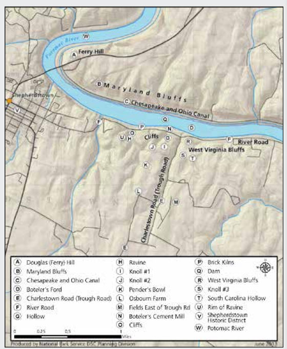
Topographic and historic sites in the battlefield and surrounding area are noted in the map below.
Maps were obtained from the Department of the Interior National Parks Service Special Resources Study Newsletter 2 (2017).